We are very happy to announce the addition of maps to our TopPlace™ Suite!

We always strive to provide additional value to our customers. Since the day we started offering only one product, we have steadily evolved into providing a suite of location context products. Now we also provide maps (map tiles) included in all the existing plans.
At no extra cost.
You read that right.
This means that all TopPlace™ customers (existing and new) can use our thoughtfully customized maps, in addition to our location context products.
Why should this Matter to You?
3 top reasons:
1. Huge savings in costs (up to 80%).
2. Development time savings (no need to wrangle with separate geo-data providers with varied license terms).
3. Streamlined user experience (our products are already customized to work well together).
Proven Performance
We have been providing maps for a while already, but only as part of one of our TopPlace™ products – the Location Page. However, in the past months we saw several clients wrangle with the integration of different maps across their website. They also struggled with the high costs of Google Maps, which increased ~1400% in 2018. The costs issue became more relevant after the Covid pandemic started.
These clients had to dedicate precious time to explore available alternatives and developers time to work on the changes.
So, we decided to suggest a few selected clients to use our maps, separately from our “Location Page” product. That worked out really well. They eventually replaced the other maps from their search pages and ended up saving thousands in monthly costs.
Now we are extending this option across all our clients, regardless of their pricing plan.
How to Get Started?
It takes 5 quick steps (about 5 minutes) to start using map tiles as part of your TopPlace service.
1. Create a “Project” in the Admin Panel:
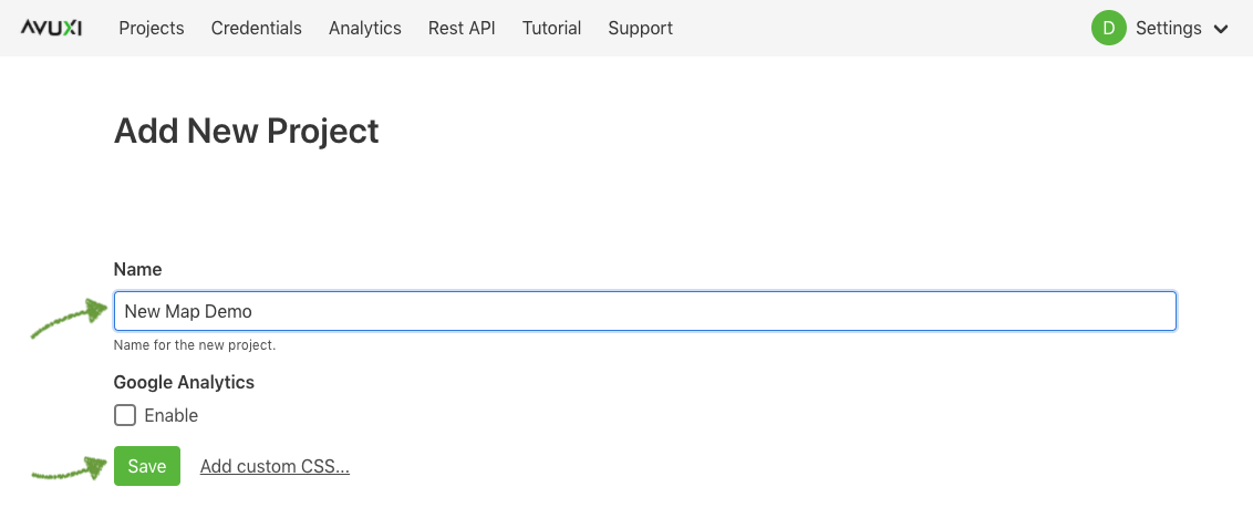
2. Select to add a “Map Layers” element:

3. Choose either a “Leaflet” or “Mapbox GL” map option, then click through the setup screens and click the green “Finish” / “Save” button to finish:

You can try to see how easy it is in this live demo.
4. You’ll get a code which contains an example on how to integrate.
5. Insert the code in your website as shown. Remember to “Enable” your “Project” before going live:

That’s it.
When is it a Good Fit for You?
1. When you need clear styled maps to display your properties and data.
2. When the license cost structure of known map providers is just too high and too complex, eating up a chunk of your precious revenues and resources.
3. When you want to have better use for your development team and have them rather focus on your core business (instead of wrangling with map APIs, curating, updating and sorting out large amounts of location data).
When it is Not a Good Fit for You?
1. You have a low volume traffic to your site (then you’re likely to benefit from the free credits from other providers).
2. You need an extensive variety of geo-data services and price is not an issue (then Google is the answer).
How come there’s No Extra Costs?
Because we are using Open Data, we don’t charge a premium on the data. However, the work and server costs required to provide a quality tiles service is not to be underestimated. A global interactive map requires hundreds of Gigabytes, sometimes even Terabytes of geo-data. For example, a typical planet-wide database used to render one of the OpenStreetMap styles has a size of ≈ 1 TB, or more, depending on the features.
This large amount of data is required to generate map tiles of 20 different zoom levels, including roads, buildings etc. Additionally, lots of processing power, very fast SSD storage, a CDN and professional knowledge are needed to render and serve the maps efficiently.
Where does the Map Data comes From?
The data used to generate the maps comes from OpenStreetMap. It is like the Wikipedia for maps, with a very rapidly growing user and contributor community. In fact, the OpenStreetMap project has become so mature and popular, that in some places its coverage rivals Google Maps. In the past few years, many large corporations have realized the value of a joint effort to keep global geo data updated. Users and contributors include well known companies like Apple, Facebook, Mapbox, Microsoft, Snap and Tesla.
Transparent Pricing
Our pricing is arguably the most transparent on the market. Our maps are priced in the same way as the rest of the TopPlace products – based on your unique users. Regardless of the amounts of data consumed by a single user, we will only account once that unique user. This means a clear understanding of your costs. No cumbersome pricing with hard to estimate costs based on credits, map loads, amount of tiles or API calls.
You can use our maps as much as needed to provide the best possible user experience to your visitors on your website. We actually encourage our clients to use location data more proactively to keep their customers better informed and engaged. We don’t “penalize” them for the use of data. The price per unique user always remains the same, regardless of how many map loads were generated by that user.
Do not hesitate to contact us, if you have any questions.
Welcome to TopPlace™!